
Deadly Flash Floods Strike Redding
- Rex Ballard

- Dec 22, 2025
- 3 min read
A powerful atmospheric river unleashed torrential rains on Northern California overnight from December 21 to 22, 2025, triggering severe flash flooding in Shasta County that claimed at least one life and prompted multiple water rescues in the Redding area. The deluge, which dumped 3 to 6 inches of rain in just hours, submerged roads, stranded vehicles, and knocked out power for thousands, turning everyday streets into hazardous waterways.

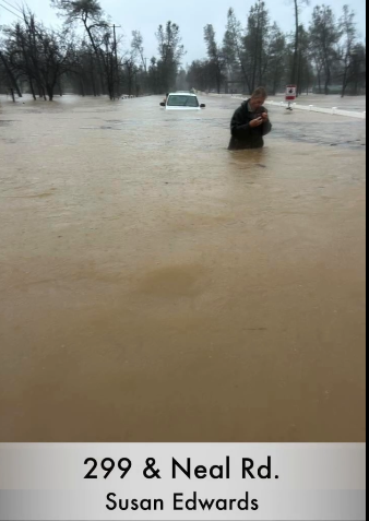
The flooding began escalating around 1 p.m. on Sunday, with a stationary band of heavy precipitation converging over south-central Shasta County, leading to rapid water accumulation in low-lying areas. Redding Mayor Mike Littau confirmed the fatality late Sunday, as emergency crews scrambled to respond to reports of trapped motorists and overflowing creeks. "This is a life-threatening situation," the National Weather Service warned, issuing flash flood emergencies for downtown Redding, Interstate 5, and State Route 299, urging residents to avoid flooded roads where even shallow water could sweep away vehicles.


Photos posted on Mike Kreuger's - Weather Norcal page https://www.facebook.com/search/top?q=mike%20krueger%20-%20weather%20norcal
Floodwaters rose dramatically in areas like Mary Lake Park, where levels surged significantly, and Shasta View Drive, which was closed after flooding entered nearby homes. Social media footage highlighted the intensity, with videos showing extreme rainfall turning roads into rivers in real time. Other areas impacted included Churn Creek, Hwy 273 from I -5 in Anderson to Market St.
Rescue operations were swift and ongoing. Redding police and fire departments conducted water rescues for stranded drivers, while in nearby Cisco Grove, nine people were saved from a flooded home. The one reported fatality took place when a motorists was trapped in their vehicle and it was swept away near Wyndham Lane and Hwy 273 in south Redding. The individual called 911, but emegency workers were not able to respond in time. Redding Electric Utility reported over 2,600 customers without power due to the storm's impacts. Major road closures compounded the crisis, including sections of Highway 273 (Branstetter and Buenaventura), Shasta View Drive, Old Alturas Road, Bonnyview Road, and disruptions on Interstate 5 near Cypress Avenue and South Bonnyview. "There is a significant amount of flooding occurring in Redding," one local storm chaser posted on social media, noting shutdowns on SR 273 north of town.
In response, Shasta County activated an Emergency Operations Center, with city staff coordinating efforts to clear streets and restore services. The American Red Cross opened a shelter at Pilgrim Congregational Church on Foothill Boulevard for those displaced, though pets were not allowed. Residents were advised to shelter in place and report emergencies, as conditions remained volatile.
The storm's effects extended beyond Redding, with flood watches covering over 41 million people statewide and heavy mountain snow in the Sierra Nevada. More rain is forecast through Christmas, potentially exacerbating flood risks in central and southern California. Officials continue to emphasize safety: "Turn around, don't drown," as even minor flooding can turn deadly.
This marks one of the most intense weather events in the region this season, highlighting the growing risks from atmospheric rivers at a time of the year when weather changes can be volatile. Rainfall totals over the past three days (Dec. 19 - 22) range from 8" at Whisketown Lake to 4.5" at the airport. The extended forecast indicates that more rain will fall (potentially another 2" - 3") through the day after Christmas. The weather should begin to clear after that except for the possibility of light rain on New Years eve and New Years day.


